Published Wednesday, October 28, 2026 · By Steve Andrews, CAA Basic Avalanche Educator · 8-minute read
Early-Season Snow in BC: The Short Version
- Snow is arriving in the Sea to Sky this week, followed by a cold spell, then a sharp warm-up around Monday and Tuesday (November 2–3).
- Cold air over a thin, early snowpack is the classic recipe for facets. A warm-up can then put a crust over them on the high, shaded slopes where the snow survives.
- If that facet/crust combo gets buried before it heals, it can become a persistent weak layer that sticks around all season.
- This isn’t just a ski-touring problem. Hikers, hunters, and anyone walking into early snow should know it too.
- The most useful thing you can do this week: go look, log what you see, share it on the Mountain Information Network, and practice with your beacon.
The Storm Is Only The Prologue
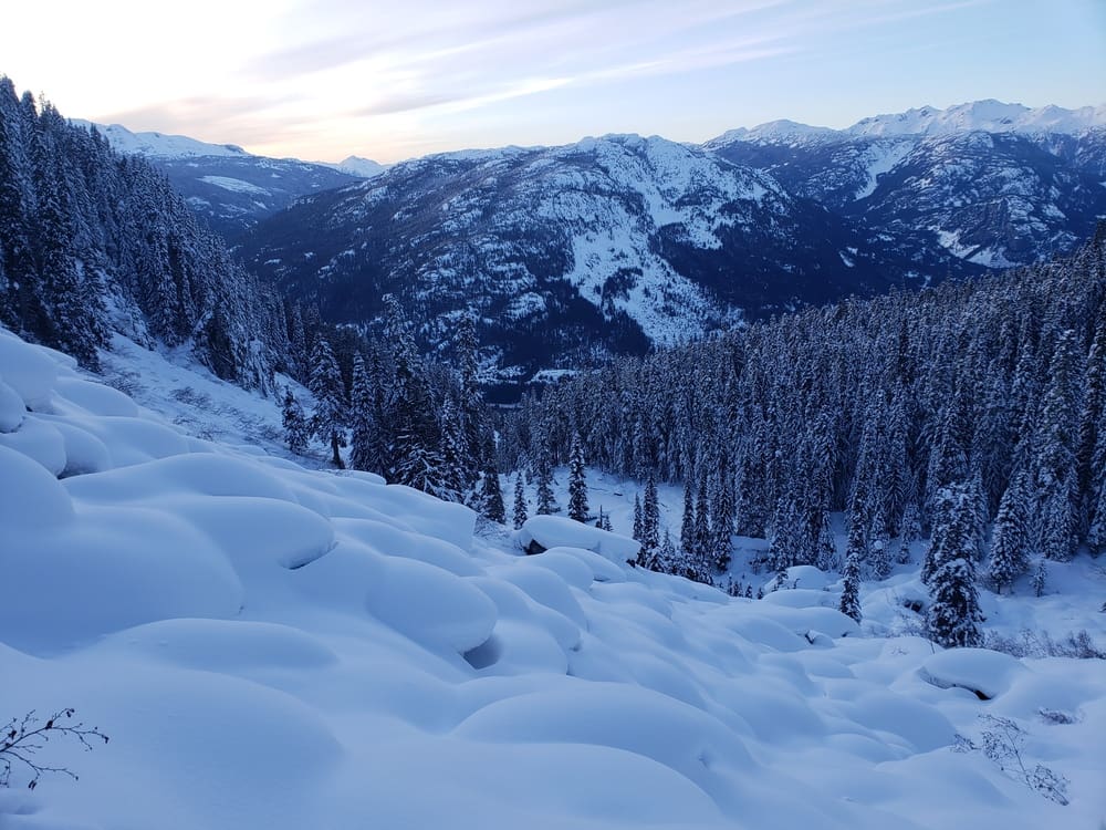
If you’re in BC and you are as excited for winter as I am, you’ve probably seen the forecast: SNOW! Up to 25 cm is forecasted over the next few days, with a freezing level possibly as low as Whistler Village.
And then… the #$*@%&! freezing level rises. Some forecasts say 3,000 m between Monday and Tuesday, to give us a nice little warm-up that could mean disaster. Other models disagree. So, in case you haven’t guessed by now, weather is kind of a crapshoot. But variability over the next week is something all the models can agree on.
What’s coming to the Sea to Sky
A generally sunny October has now given way to some disturbance, bringing some precipitation with cooler temps. Models are disagreeing on how much, but they all show a decent amount of snow today (Tuesday the 27th) and Wednesday, with cold temperatures to follow.
For the real forecast, use Avalanche Canada’s mountain weather and early-season information at avalanche.ca. In the US, find your local avalanche centre at avalanche.org.
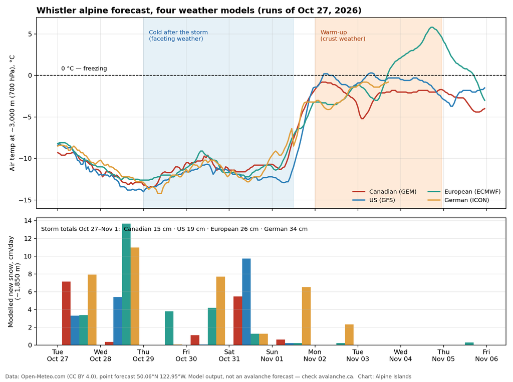
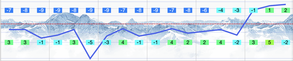
Here’s what the major weather models showed for the Whistler alpine on the morning of October 27. Storm totals through Sunday range from about 15 cm (the Canadian model) to 34 cm (the German model), with the European and US models in between. Then all four warm the air near 3,000 m from roughly −12 °C to close to freezing by Monday and Tuesday. The US model puts the freezing level above 3,000 m on both days, and the European model pushes even warmer by Wednesday. The models still disagree on how warm, and how high, but not on the swing itself.
Beware the gradient
With a thin snowpack, the ground plays a huge part in what’s happening to the snow. If the cold air above the surface is significantly below freezing, this is the main ingradient (terrible pun intended) for faceting.
Now the warm-up could be a good thing in that it causes the surface to melt, which, if it’s sunny, could mean we’re back to bare rock. But on shaded slopes at high elevation where the snow is preserved, those facets could see a crust on top of them. And if that gets buried before a rain event or some other way for it to heal, we could possibly be set up for a weak layer that will give us nightmares all winter.
New to this? How do facets form?
Early in the season, the ground under the snow is still holding summer and fall warmth, sitting near 0 °C. When the air above drops well below freezing, a thin snowpack ends up with a steep temperature difference from bottom to top (AKA Temperature Gradient). Water vapour moves through the snow from warm to cold, and the rounded, well-bonded grains regrow into angular, sugary crystals called facets. A common rule of thumb is that faceting kicks in at around 1 °C of change per 10 cm of snow, which a shallow snowpack under a cold, clear sky can blow past easily (Utah Avalanche Center). Facets bond poorly, and they can take weeks or longer to gain strength once they’re buried.
Where the early snow survives
The big thing here is finding out where the snow survives, and what kind of snow it is. That can only be done by getting out there and checking it out. It’ll be elevation- and aspect-specific, and can even be down to the micro-feature for where the faceting stays and whether it can heal.
So if this next week or so in the forecast is any indicator of the season ahead, we may be in for a doozy if the pattern continues. Nobody likes to make bad predictions, so if we can get some beta from a variety of zones, that will be the best way to really understand how this snowpack is forming, and whether we want to take up canasta this winter instead.
This is shaping up to be a season of knowing a certain zone really well, not a few zones kinda well.
Steve’s Shower Thoughts
What Is a Persistent Weak Layer?
A persistent weak layer is a layer in the snowpack that resists bonding to the snow around it for a long time, and it’s usually made of facets, surface hoar, or depth hoar. The facet/crust combo I’m worried about this week is one of the classic versions: facets can grow above or below a crust, and crusts that form early in the season often develop weak facets next to them (Avalanche Canada, avalanche.org). The danger is that a layer like this can sit quietly under months of new snow, then fail when a big storm finally loads it with enough mass.
If you want to practise reading the weather patterns that build these layers, try Pattern Reader, the free avalanche-weather trainer here on Alpine Islands.
Not in the Sea to Sky?
People further inland might be a bit more accustomed to early-season faceting, as is more common with a continental snowpack. But it seems that with this El Niño winter, all bets may be off for what a “normal” season is from here on out.
NOAA’s Climate Prediction Center has had an El Niño Advisory in place since summer, and its September update gave a greater than 90% chance of a very strong event this fall and winter. The BC River Forecast Centre notes that El Niño winters are typically associated with warmer-than-normal conditions here, though the impacts vary a lot from event to event. Warmer storms and bigger temperature swings are exactly the kind of weather that builds crusts.
Even if you’re somewhere more accustomed to a continental-style snowpack, it’s wise to pay attention to the weather patterns as we shift from fall to winter. Snowfall followed by clear/cold temps is a recipe for facets. Snow followed by rain, followed by cold temps, and then snow again means a buried crust. All of these can set up a Persistent Weak Layer, which is nobody’s friend in avalanche terrain, and will haunt us all season.
It catches people off guard in the worst way possible, lulling us into complacency after months of nothing happening until one day, it just decides to release and cause havoc. So even though the snow isn’t deep, it’s worth paying attention to the weather. Temperature variability is more important than ever now, so pay attention to what happens in between storms.
What to Do This Week
It’s worth going out for a check just to take notes and share with the wider community. Here are some tips if you are getting restless:
- Go for a walk, and log where the snow sits: date, elevation, aspect. Photos are super helpful. Comparing it to next week after the warm-up will help us understand this base layer much better before it gets buried.
- Practice with your beacon before you’re in avalanche terrain. Our free beacon practice app times your searches.
- Share what you see: post observations to the Mountain Information Network on avalanche.ca, or to your local centre in the USA via avalanche.org.
Email me and tell me where you’re seeing snow stick.
I’ll share a roundup of what people see and together we can build a record to help people stay safe once this primary layer gets buried or washed out.
Want the roundup when it lands? Join the Alpine Islands newsletter.
P.S. This is the type of info we discuss week to week in the Dojo. Permitting is taking longer than usual, but if all goes well, we’ll get the proper authorization by Christmas. Stay tuned, or join the list to receive more information!
Frequently Asked Questions
Can you trigger an avalanche when there’s only a little snow?
Yes. Early-season avalanches tend to start where the early snow collects first, like alpine bowls, gullies, and slopes below ridgelines, and with a thin snowpack even a small slide can be serious because of the rocks, stumps, and other hazards underneath. Trauma is just as deadly with avalanches as being buried, so even a small slide can pound you into something painful.
How do facets form in early-season snow?
Facets form when there’s a big temperature difference across the snowpack, usually a still-warm ground under cold air, which is common when a thin early snowpack meets a cold, clear spell. The rule of thumb is about 1 °C of change per 10 cm of snow.
What is a facet/crust layer?
It’s a hard crust, from rain or melt-freeze, with weak faceted snow above it, below it, or both. Once buried, it can act as a persistent weak layer and produce avalanches weeks or months later.
How will El Niño affect the 2026–27 ski season in BC?
NOAA expects a very strong El Niño this winter, and El Niño winters in BC are typically warmer than normal, though no two events play out the same. For backcountry travellers, warmer storms and bigger temperature swings mean more chances for crusts and facets to form.
Where can I check avalanche conditions before regular forecasts start?
In Canada, start at avalanche.ca for early-season conditions and the Mountain Information Network, where other backcountry users post what they’re seeing. In the US, find your local centre through avalanche.org.
Sources and Data
- Forecast chart: Open-Meteo point forecast for the Whistler alpine (GEM, GFS, ECMWF, and ICON models), runs of October 27, 2026. CC BY 4.0.
- El Niño outlook: NOAA Climate Prediction Center, ENSO Diagnostic Discussion.
- El Niño and BC winters: BC River Forecast Centre, Snow Survey and Water Supply Bulletin (June 15, 2026).
- Faceting and temperature gradients: Utah Avalanche Center.
- Persistent weak layers and facet/crust layers: Avalanche Canada glossary and Avalanche Encyclopedia (avalanche.org).
- Persistent slabs in continental snowpacks: Colorado Avalanche Information Center.
- Early-season conditions and user reports: Avalanche Canada and CBC News.
This is education and observation, not an avalanche forecast. Always check the official forecast for where you’re going.

Steve Andrews is a lifelong adventurer since before he could walk. A skier since age 2, snowboarder since 11, he began his guiding career in 2007. He has a passion for teaching people how to fish, and helping them discover their own power in the mountians. He started Alpine Islands to give people a different take on achieving mastery in the wild (hint: you’re never a master of Mother Nature). He lives in Horseshoe Bay, British Columbia with his partner and two kids.